Kansas Geological Survey report assesses health of the High Plains Aquifer
LAWRENCE — A new publication from the Kansas Geological Survey at the University of Kansas assesses current conditions and trends in water levels and groundwater usage in the High Plains Aquifer, the state’s most economically important groundwater resource.
The report summarizes current regional conditions of the aquifer and evaluates progress toward sustaining or prolonging the life of the largest groundwater resource in the state. It also showcases the progress made in areas that have adopted voluntary water conservation measures to reduce groundwater pumping and extend the life of the aquifer.
“The availability of more than 25 years’ worth of high-quality water-level and water-use data for the aquifer makes it possible to provide a sound assessment of the aquifer status,” said Donald Whittemore, KGS emeritus senior scientist and lead author of “2023 Status of the High Plains Aquifer in Kansas, KGS Technical Series 25.” “The results can help irrigators, groundwater management districts, and other local and state agencies determine how successful conservation efforts have been.”
The High Plains Aquifer, which underlies portions of eight states from South Dakota to Texas, is the primary source of water for western Kansas. It includes the Ogallala Aquifer of western Kansas and the Great Bend Prairie and Equus Beds aquifers in the south-central part of the state.
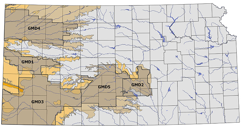
The new publication provides data for each of the state’s five groundwater management districts, created to provide local management of water resources. All five GMDs overlie the High Plains aquifer.
Groundwater levels in the Ogallala portion of the aquifer (GMDs 1, 3 and 4) have dropped significantly since the start of widespread irrigation of cropland in the 1940s and 1950s. In some areas, less than 40% of the original aquifer thickness remains.
This new assessment found that groundwater levels could be sustained — defined as a zero water-level change — in most of the imperiled areas of western Kansas for at least one to two decades by reducing pumping between 18% and 32%.
In south-central Kansas, the Equus Beds aquifer in GMD2 has seen stable water levels during the last 25 years while the GMD5 Big Bend Prairie region shows a slight decline. The pumping reduction needed to achieve districtwide stable water levels in GMD5 is 1.6%.
Analysis of data gathered in GMD1 in west-central Kansas and a part of GMD4 in northwest Kansas show water conservation measures adopted in these areas have slowed the rate of water use and water-level declines. By determining water use under similar climatic conditions before and after conservation measures were implemented, KGS researchers were able to determine how much reduction in pumping could be attributed to irrigation efficiency and how much was the result of a decrease in irrigated area.
In Sheridan County in GMD4, the state’s first Local Enhanced Management Area (LEMA), the Sheridan-6 LEMA, has realized water savings attributed to irrigation efficiency of about 23%, with an additional 1% of savings related to a decrease in irrigated area, since it began operation in 2013. The average annual groundwater level decline in the SD-6 LEMA for 2013–2022 was 0.5 feet compared to 2 feet in the pre-LEMA years of 2002-2012. LEMAs allow local stakeholders to develop plans to reduce irrigation pumping in a specified area. GMDs and the Kansas Department of Agriculture Division of Water Resources oversee compliance monitoring and enforcement.
The success of the Sheridan-6 LEMA led to the formation of a districtwide LEMA in GMD4 in 2018. That LEMA has yet to have a significant effect on water use or water-level declines.
Two LEMAs have been established in GMD1, the first in Wichita County in 2021 and the second in the district’s four other counties in spring 2023. Water Conservation Areas — conservation plans submitted by individual producers — were established in all five counties before the LEMAs were formed.
Analysis showed a total reduction in pumping districtwide in GMD1 of about 24%, with 10.5% due to irrigation efficiency and nearly 14% due to decreases in irrigated acreage.
Wichita County has seen reductions in pumping of about 40%. Water levels in parts of this county and other areas in the district have fallen so low that large-scale irrigation pumping has been reduced or is no longer possible. As a result, farmers are adjusting by reducing acreage, changing cropping patterns and adopting technologies to reduce water usage.
“Our results show that the only way to slow water-level declines is to reduce pumping in conjunction with modification of agricultural practices,” said Jim Butler, KGS senior scientist and one of the report’s co-authors. “Use of more efficient irrigation technology by itself will not slow these declines. As has been shown in Kansas and elsewhere, efficient irrigation technology must be coupled with a binding agreement to reduce pumping if we are to make a difference.”
In GMD3 in southwest Kansas, where several WCAs but no LEMAs have been established, groundwater use since 2019 appears to have dropped by nearly 13% compared to 2005-2018.
“Additional years of monitoring are needed to confirm this reduction and how much is the result of decreases in irrigated area or decreases in irrigation application rates,” Butler said.
The KGS and the KDA-DWR measure groundwater levels in 1,400 wells across the High Plains Aquifer annually. In addition, water-right holders are required to report water use annually to the KDA-DWR, which verifies them through various means.
"2023 Status of the High Plains Aquifer in Kansas" by Whittemore, Butler and Brownie Wilson is available both in print and online. Two online-only appendices provide additional information. Print copies may be purchased at the Kansas Geological Survey in Lawrence, at the Kansas Geologic Sample Repository in Wichita or by contacting the KGS publications sales office.
Photo: Extent of the High Plains aquifer in Kansas and groundwater management district boundaries.