Architecture professor's book analyzes cities’ geometry
“The lights are much brighter there
“You can forget all your troubles, forget all your cares
“So go downtown …”
— From the song “Downtown,” written by Tony Hatch, 1964
LAWRENCE — The dynamism of cities is the stuff of song and story, and it has been studied from an almost infinite number of angles and disciplines – from urban planning to psychology. But in his new book, a University of Kansas professor has found a new viewpoint from which to study cities – space and its geometry.
 “Without satellite images, it would have been impossible to do a study like this,” said Mahbub Rashid, professor of architecture, design & planning, referring to his new book “The Geometry of Urban Layouts: A Global Comparative Study” (Springer International Publishing, 2017).
Rashid used Google Maps to look at four-square-mile areas in the center (i.e. downtown) of 105 cities in both developed and developing nations and analyzed the findings in various ways, including measuring the total length of streets, the number of street corners, intersections, dead ends and more, and figuring relations among these factors.
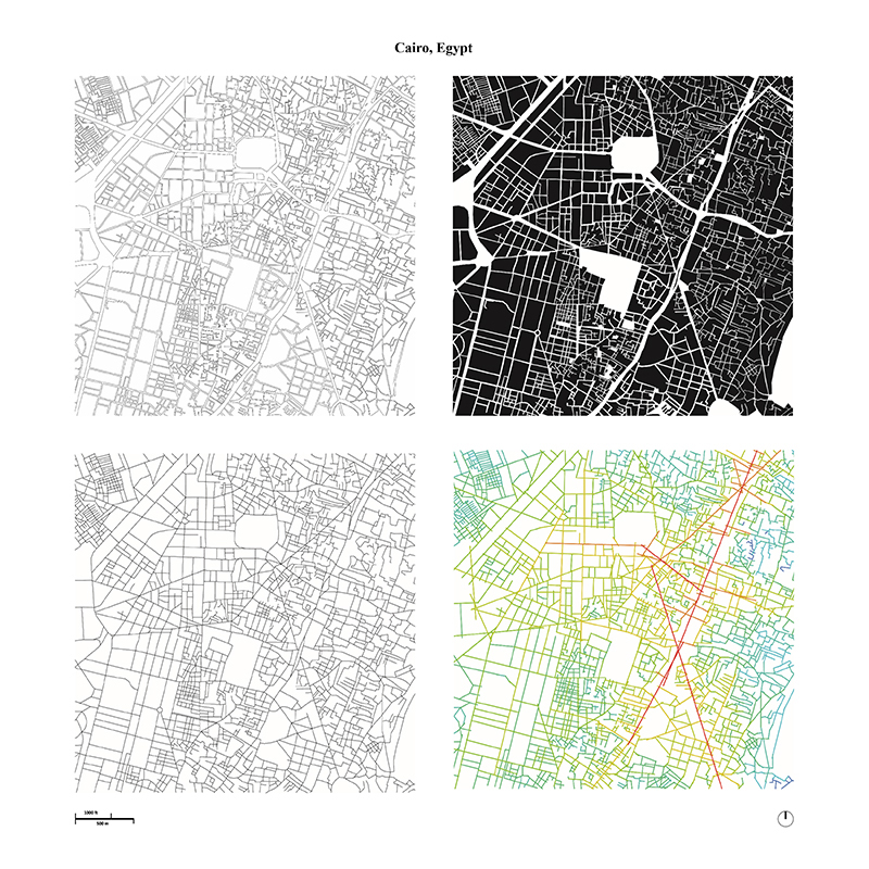
The book contains representations of each city in four separate maps, one each showing the street network, the urban blocks, the spatial-experience structure and the street center lines.
“The most regular city is Buenos Aires; the most complicated is Cairo,” Rashid said.
Rashid said he was motivated to write the book because, even though “we know a lot about cities’ economic and political motivation … we rarely talk about the geometry of the city, which is the basis for any city, I guess.
“They’ll talk about the human geography but rarely about the geometry of the city. So I said, ‘Let’s compare, between developing and developed economies.’ … People are interested in seeing the relationship between the physical nature of the city and the social and economic elements.”
Rashid said he was struck by the fact that cities, like living creatures, “follow the rank size rule.”
“When you talk about big animals like elephants, there are relatively few of them. But when it comes to smaller animals like mice, they are large in numbers. There are few cities like New York, Los Angeles, Atlanta, but many more like Lawrence. The resources required to keep big cities are huge. It doesn’t happen just anywhere.”
But there are variances even among world capitals, Rashid said.
“Cairo has a high number of urban blocks … whereas Moscow has few urban blocks compared to other cities,” Rashid said.
Another pattern that became clear, he said, was that “the amount of open space is much higher in developed economies than in developing ones. Open spaces are related to human health.”
He noted, for instance, that New York’s Manhattan Island street grid was laid out in 1811, and that Central Park was created many years later, in the 1860s, by renowned landscape architect Frederick Law Olmsted, who took out streets so city dwellers would have a place to enjoy fresh air and recreation.
Rashid, who was born and raised in Bangladesh, said he likes New York a lot, but that Chicago, Philadelphia and New Orleans are his favorite American cities.
“I love European cities because they are livable and walkable,” he said. “Cities are about opportunities, economy and agglomeration. Because they come together, people can benefit from each other.”
The six most exceptional cities
Based on 44 different geometric – topological, metric and fractal – measurements, Rashid’s book lists a series of the world’s “most exceptional” cities. Some are notable for their density, or high intensity, while others are notable for their low intensity, and one is notable for its mixed, or contrasting, levels of intensity.
1. Cairo (high intensity)
2. Moscow (low intensity)
3. Kiev, Ukraine (low intensity)
4. Buenos Aires (low intensity)
5. Bogota (contrasting intensity)
6. La Paz, Bolivia (high intensity).
Image: Four views of Cairo, clockwise from top left: The street network, an urban block map, an axial or spatial-experience map showing the fewest number of the longest straight lines needed to cover all streets and complete all circulation rings, and a street centerline map.